Conservation of Key Underground sites: the database
- Introduction to underground sites
The group was established at the AC4 as the IWG on "Transboundary programme – habitats: Data compilation"
texts and maps compiled by Tony Mitchell-Jones, updated by the Secretariat in 2016Introduction
Underground habitats
Underground habitats, such as caves, mines, fortifications and tunnels, play a vital role in the life-cycle of many European bat species, which use them as hibernation, breeding and transitional roost-sites, including during migration. Particularly in the latter case, it is often difficult to establish the importance of sites, owing to the transitory nature of their occupation. However, such sites may often be key to the survival of a species in a particular region of the continent. The significance and threats to such sites have been highlighted in the IUCN Microchiroptera Action Plan (2001).
Recognising the importance of underground habitats and the many threats they face, Eurobats Resolution 2.4 (Bonn, 1998) set in place a project to identify and list the most important underground habitats across the Agreement area. Listing is considered an important step towards ensuring that important sites are appropriately protected and managed to maintain their continuing value to bats. In parallel with this data-gathering project, the Advisory Committee was instructed to prepare guidelines on the protection and management of underground habitats. These were published in 2007 as EUROBATS Publication Series No 2.
Guidance on the selection of important underground habitats by Parties and Range States, including a description of the information required, was prepared and adopted by the Advisory Committee in 2000 (see here), with Parties encouraged to submit data using a standardised data structure. The importance of this work was reiterated in Resolution 4.3 (Sofia, 2003), which also called on Parties to ensure that listed sites are protected by law and, where appropriate, physically protected against unauthorised entry. Given the uneven distribution of both bat species and populations, as well as underground habitats, across the Agreement area, Parties and Range States were asked to use their own judgement to select their most important sites.
Sites submitted by Parties and Range States
By the time of the 7th Meeting of Parties (Brussels, 2014) 1,895 sites had been submitted for inclusion in the list.
Totals for Parties and Range States are shown in the table below (Parties are shown in bold Italic):Country Number of sites Albania 6 Algeria 26 Austria 46 Belarus 7 Belgium 97 Bulgaria 86 Croatia 55 Czech Republic 62 Denmark 6 Estonia 8 Finland 6 France 224 Georgia 4 Germany 301 Greece 67 Hungary 82 Ireland 14 Italy 109 Latvia 20 Lithuania 6 Luxembourg 1 Montenegro 10 Morocco 27 Norway 24 Poland 189 Portugal 76 Romania 57 Russian Federation 26 Slovakia 84 Slovenia 65 Switzerland 5 Syrian Arab Republic 10 Ukraine 35 United Kingdom 54 Total 1895 In order for these nationally-important sites to benefit from listing, it is essential that their value is widely recognised. Resolution 6.16 (Prague, 2010) implements the Eurobats Conservation and Management plan for 2011-2014 and includes an instruction that: “The list of internationally important underground sites for bats identified by Parties and reviewed at the 15th Meeting of the Advisory Committee and site assessment criteria should be published in a suitable format and be accessible through the EUROBATS website.”
- List of internationally important underground sites
List of internationally important underground sites
Site lists
The Eurobats underground sites database contains details of 1,891 sites across the Agreement area. The amount of information available for sites varies, but each has a name, geographic coordinates (of varying precision) and an indication of the type of site. Many sites also have information about the main way in which the site is used by bats, whether the site is physically protected against unauthorised access and whether there are threats to the site. Information about the bats occupying the site is also variable in detail. Some sites have only a figure for the number of bats using the site, others have dated (year) counts of each species present at the site and there are many variations between these two extremes.
Publication format
Sensitivity
Recognising the need to balance the value of publication against the sensitivity of some underground sites to disturbance and the threat posed by uncontrolled tourism, the Advisory Committee offered Parties and Range States the option of restricting publication on a site by site basis. Three options were offered:
A - Publication of standard details (site name, location, species list)
B - Limited publication; no site name, location degraded to 1° (approx. 111 km)
C - No publication
The table below shows the number of sites in each category:
Publication code No. of sites A – full publication 1,447 B – partial publication 433 C – no publication 15 Details published
For each country, an outline map showing the location of each site is provided. For each site, the published data consist of the site name (or ‘Underground site’, where the name is not to be published), the type of site, geographic location and a list of species recorded at the site.
Summary data
The Eurobats database is the largest international collection of data on underground sites for bats in Europe and so contains a unique insight into the way in which bats use underground sites across this area. The following sections summarise some of this data:
Type of site
The table below shows the proportion of each site type held in the database:
Site type No of sites Percent Cave 900 47.59% Mine or Quarry 481 25.44% Building/cellar 183 9.68% Fortification 181 9.57% Other 63 3.33% Road/rail tunnel 45 2.38% Waterway tunnel 19 1.00% Ice-house 8 0.42% Artificial bat site 5 0.26% Souterrain or burial site 3 0.16% Church 3 0.16% Total 1891 100% The same data are illustrated on the map below, which shows the importance of cave sites, particularly in the foothills of mountain ranges. In northern Europe, or in areas without significant mountain ranges, mines, fortifications or other types of underground site become more important.
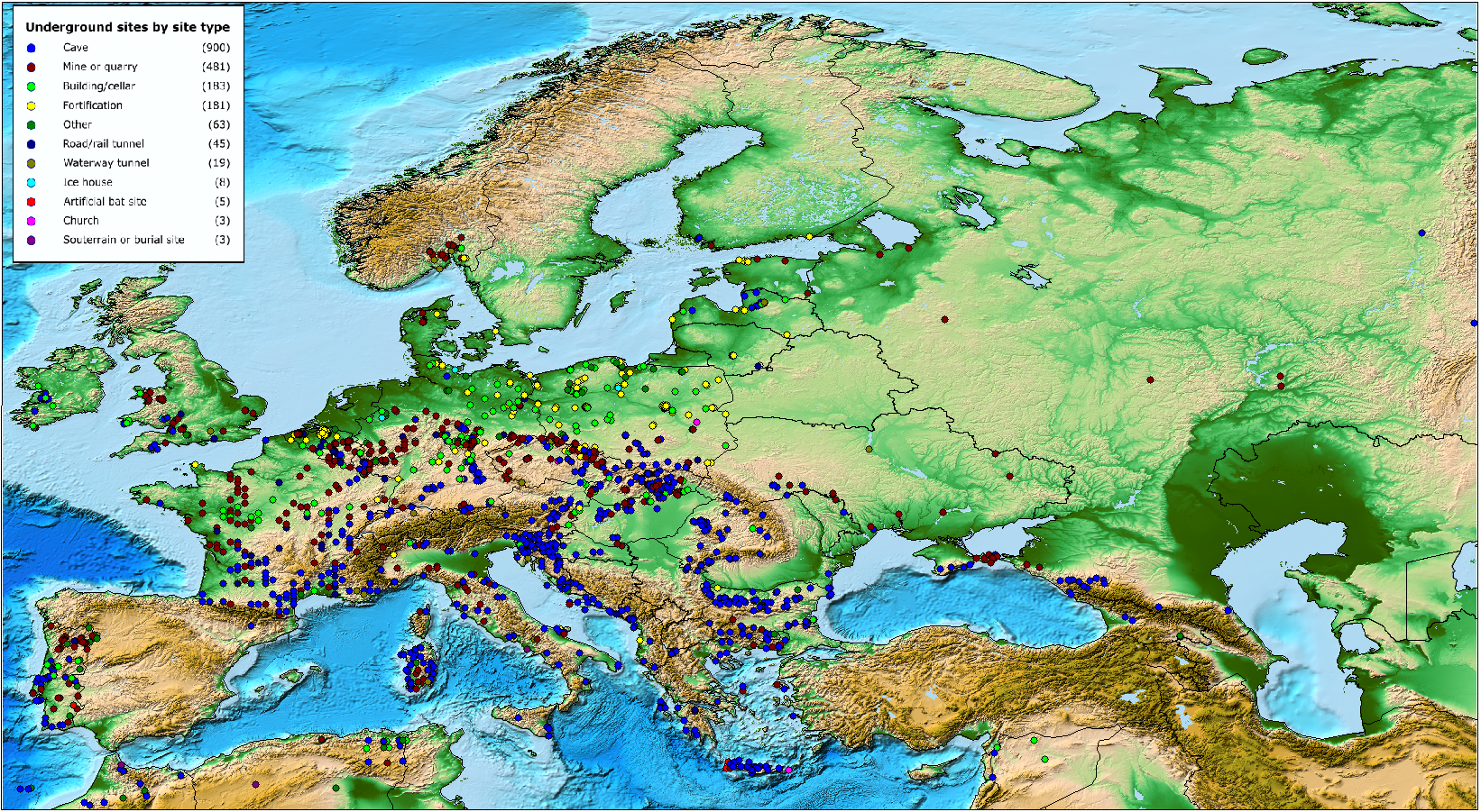
The boundaries shown on the map do not imply official endorsement or acceptance by the United Nations.
- Bat species
Species of bats
Although data are incomplete, sufficient data are available to give a fairly detailed picture of the extent to which different species use underground sites.
The table below is dominated by the two widespread and cave-dependent Rhinolophus species, Greater and Lesser horseshoe bats. These species use underground sites for both breeding and hibernation, though in the northern part of their range they typically seek out buildings for breeding.
The Greater mouse-eared bat Myotis myotis, another widespread cave-dependent species, uses underground sites in a similar way to the horseshoe bats, typically breeding in churches or other large building in the northern part of its range.
Schreiber’s bat Miniopterus schreibersii has a more southerly distribution and uses caves, or other underground sites throughout the year. It forms particularly large colonies and sometimes makes seasonal long-distance movements between caves.
Species No of Sites Best site Best count Miniopterus schreibersii 402 11003, France 70000 Pipistrellus pipistrellus 73 Erna, Slovakia 58000 Myotis myotis 473 MRU, Nietoperek main system fortifications, Poland 23627 Myotis daubentonii 425 Daugbjerg Kalkgruber, Denmark 17700 Myotis capaccinii 134 Ivanova Voda cave, Bulgaria 15500 Myotis myotis/oxygnathus 14 Shpella e Velces, Albania 10000 Myotis myotis/blythii 139 Peștera de la Izvorul Tăușoare, Romania 8855 Barbastella barbastellus 260 Canyon, Russian Federation 7000 Rhinolophus euryale 236 Orlova Chuka cave, Bulgaria 6300 Myotis emarginatus 285 Madzharovo Mining Complex, Bulgaria 6100 Myotis dasycneme 137 Mønsted Kalkgruber, Denmark 4600 Nyctalus noctula 28 Peștera Ungurului, Romania 4500 Rhinolophus mehelyi 74 Orlova Chuka cave, Bulgaria 4200 Myotis nattereri 326 MRU, Nietoperek main system fortifications, Poland 4042 Myotis blythii 141 Karabudakhkent, Russian Federation 4000 Eptesicus nilssonii 114 Piusa, Estonia 1972 Rhinolophus ferrumequinum 630 Peştera Muierilor, Romania 1597 Rhinolophus hipposideros 647 Javoricske jeskyne, Czech Republic 1514 euryale/blasii 16 Grota Haiducilor, Romania 1500 Myotis punicus 14 Grotta Is Angurtidorgius, Italy 1500 Plecotus auritus 330 Shtolnya Gory Verblud, Russian Federation 1482 Rhinolophus blasii 50 Golyamata Vapa cave, Bulgaria 1430 Myotis brandtii 105 Shtolnya Gory Popova, Russian Federation 1000 Myotis mystacinus 125 89001, France 799 Myotis mystacinus/brandtii 152 Dobšinská ladová jaskyna, Slovakia 527 Myotis escalerai 9 Aljezur I, Portugal 400 Pipistrellus kuhlii 2 Hdjar el Diss, Algeria 255 Pipistrellus sp. 10 Kulmbach, Plassenburg; Bavaria, Germany 216 Myotis sp. 37 Lamego I, Portugal 212 Eptesicus serotinus 149 Zbojnícka jaskyna, Slovakia 182 Myotis bechsteinii 151 Havixbeck, Meyer well; North-Rhine Westphalia, Germany 172 Hypsugo savii 12 Grotte de Guelif - Oum el Bouaghi, Algeria 167 Unidentified 23 Limnon, Kastria, Greece 100 Plecotus sp. 47 Zachlorou railway tunnel, Greece 80 Pipistrellus nathusii 4 Volvi lake cavern, Peristerona, Greece 50 Plecotus austriacus 123 Lubiaz, cloister cellar (dolnoslaskie), Poland 14 Tadarida teniotis 2 Grotte de Djedi Trad, Algeria 4 Myotis alcathoe 6 Vodnite Dupki cave, Bulgaria 3 Pipistrellus pygmaeus 4
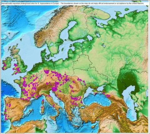
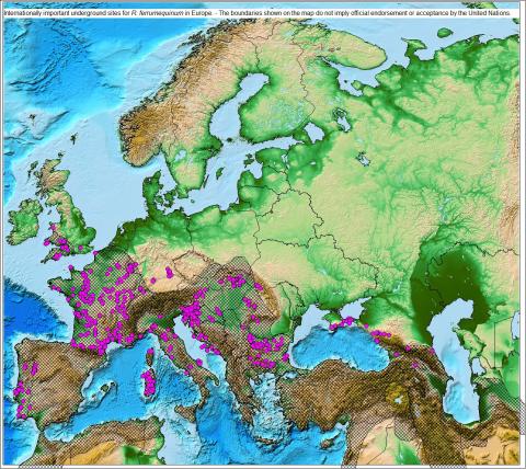
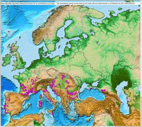
Heidelberg, Schloss; Baden Württemberg, Germany 3 Vespertilio murinus 8 Rablloch, Naas, Austria 2 Nyctalus leisleri 2 Heidelberg, Schloss; Baden Württemberg, Germany 2 Plecotus macrobullaris 1 Veternica, Croatia 1 The following maps show internationally important underground sites for the Lesser and Greater horseshoe bat as well as for Schreiber's bat. The shaded areas represent the distribution area of the respective species as described in the European Mammal Assessment (IUCN).
The boundaries shown on the following maps do not imply official endorsement or acceptance by the United Nations.
- Underground sites with most bat species
Underground sites with most bat species
The importance of any particular underground site needs to take into account not only the species and number of bats present, but also the location of the site. For example, underground sites with small numbers of bats in Scandinavian countries may be important in a national or even regional context, as they provide an essential resource for the bats in that region. Nevertheless, sites with very large numbers of bats are undoubtedly of European importance and deserve the highest level of protection.
The table lists all 34 sites with 10,000 or more bats recorded.
Country Site name Max count Romania Sura Mare Cave 81,134 France 11003 70,000 Slovakia Erňa 58,049 Bulgaria Devetashkata cave 45,503 Bulgaria Parnitsite cave 42,410 Romania Huda lui Papara cave 40,329 Croatia Trbušnjak šplilja 39,000 France 13002 35,250 Poland MRU, Nietoperek main system fortifications (Iubuskie) 32,400 Croatia Kuštrovka špilja 28,350 Bulgaria Dyavolskoto Garlo cave 28,010 Croatia Vištičina jama 27,975 Croatia Tradanj šplilja 24,500 Portugal Marvao I 21,505 Bulgaria Troevratitsa cave 18,050 France 16001 17,100 France 19001 15,157 France 81004 15,046 Bulgaria Urushka Maara cave 14,351 Germany Bad Segeberg, Kalkberg cave; Schleswig-Holstein 13,595 Bulgaria Gabarnika cave 13,061 Portugal Figueira Castelo Rodrigo 13,054 Bulgaria Golashkata Peshtera cave 12,784 Bulgaria Yarasa-Ini cave 11,502 Ukraine R-50 11,500 Bulgaria Orlova Chuka cave 11,131 Germany Spandau Citadel; Berlin 11,078 Slovenia Škocjanske jame in Tominčeva jama 10,417 Bulgaria Madzharovo Mining Complex 10,400 Hungary Kiskőháti-zsomboly 10,385 Slovakia Dielik 10,378 France 09007 10,070 Bulgaria Hilyadite Ochichki 10,010 France 11004 10,000 These sites are distributed across Parties and Range States as shown:
Country No of Sites Bulgaria 11 France 7 Croatia 4 Germany 2 Portugal 2 Romania 2 Slovakia 2 Hungary 1 Poland 1 Slovenia 1 Ukraine 1 Main usage by bats
Although some sites are occupied by different species at different times of the year, contributors were asked to indicate the main usage of each site. The table is dominated by sites used primarily for hibernation, though all-year and maternity sites become more important in the Mediterranean region (see map).
Usage No of sites Hibernation 1239 All year 283 Maternity 227 Transient/migratory 42 Swarming 1 Other use 40 Undefined 32 - Site lists per country
Site lists for each Party or Range State that submitted data can be found by clicking on the country name. For each country, an outline map showing the location of each site is provided. For each site, the published data consist of the site name (or ‘Underground site’, where the name is not to be published), the type of site, geographic location and a list of species recorded at the site.
The boundaries shown on the following maps do not imply official endorsement or acceptance by the United Nations.